
The Wreck Today: The Mosher lies badly broken and scattered on rock bottom. The stern is at a depth of about 15 feet with the bow remains sloping down to about 22 feet. Our attempts to locate this one have been thwarted because of poor (zero) visibility and the uneven rocky bottom. Old time divers have visited the area so we know that this wreck lies near the area reported.
There is a great amount of boat traffic, and often large numbers of fishermen in this area which make searching the site difficult. In addition, be careful not to end up on any of the nearby reefs like the Amaretta Mosher.
There is a great amount of boat traffic, and often large numbers of fishermen in this area which make searching the site difficult. In addition, be careful not to end up on any of the nearby reefs like the Amaretta Mosher.

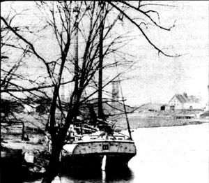
Amaretta Mosher
Additional information on the Amaretta Mosher is on page 128 of Erie Wrecks West.
Location: Starve Island Reef, WSW from 7 foot mark on chart to 15 feet
Coordinates: PA Reef: 41 36.79 82 48.86 , wreck 41 36. 767 82 48.900
Official #: 389
Lies: bow southwest, scattered Depth: 22 feet
Type: schooner Cargo: coal
Power: sail, 3 masts
Owner(s) J.M. Shacket of Marine City & Captain David Hutchinson of Port Huron
Built: 1867 in Ashtabula, Ohio by Gershom A. Thayer
Dimensions: 134’9” x 24’8” x 10’9” Tonnage: 300.91 gross 285.87 net
Date of Loss: Saturday, November 23, 1902
Cause of Loss: storm